The following shows our current plans for deploying the New Mexico Tech 3-dimensional lightning mapping system during STEPS. The new layout is based on a reconnaissance trip into the area by Paul Krehbiel and Bill Rison on Oct 21-24, during which we talked with a number of landowners about the use of possible sites. We were able to identify and arrange for the use of about half of the sites shown below and should have no difficulty arranging for the remaining sites.
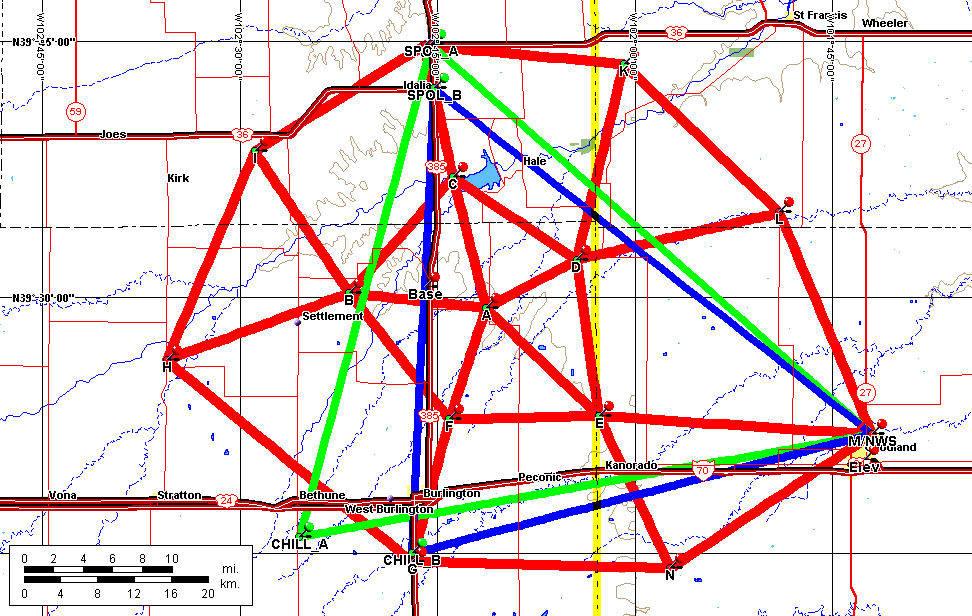
Based on the initial site selection and detectability issues, the interior part of the network will have five stations located at the vertices of a pentagon and one station in the approximate center of the pentagon. A minimum of six stations are needed for good 3-dimensional locations, and the central core will provide this. Eight stations will be located at varying distances around the pentagon to extend the coverage over a wider area, for a total of 14 stations.
Figure 1. The Lightning Mapping Network. Fourteen stations are to be deployed at the locations shown. The green and blue triangles show two possible layouts fo the triple Doppler network. The green triangle is based on the CSU-CHILL radar being located in the Bethune area; the blue triangle is based on CHILL being at the Burlington-Kit Carson County airport, south of Burlington (see further description below). The lightning mapping network will provide high-resolution coverage in and around the triple Doppler region between the radars and good-quality coverage to well outside the radar network.
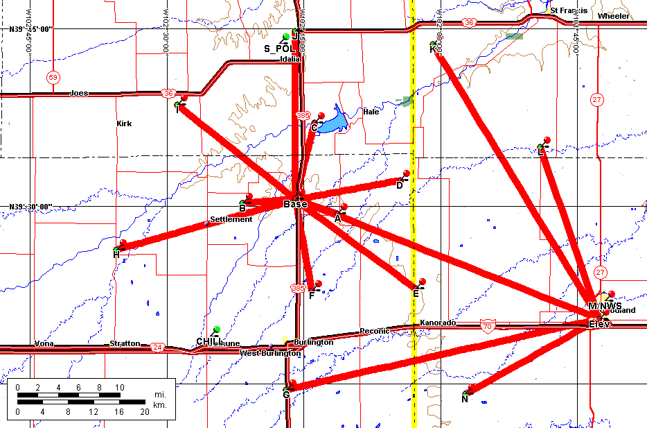
Figure 2. Communications links for the lightning mapping stations. The central and western stations will be linked by wireless modems to a central location (Base) on high ground along Highway 385 north of Burlington, and from there to our central control and processing site near the National Weather Service office in Goodland. The ethernet link may be via a grain elevator in Goodland. The southern and eastern stations will communicate directly to Goodland. The links will be used to control the operation of the stations and hopefully also to process some of the observations in real-time. Complete data will be recorded locally at each site on DAT tape for post-processing. A lightning interferometer may be operated at the Base station or at one of the other central stations.
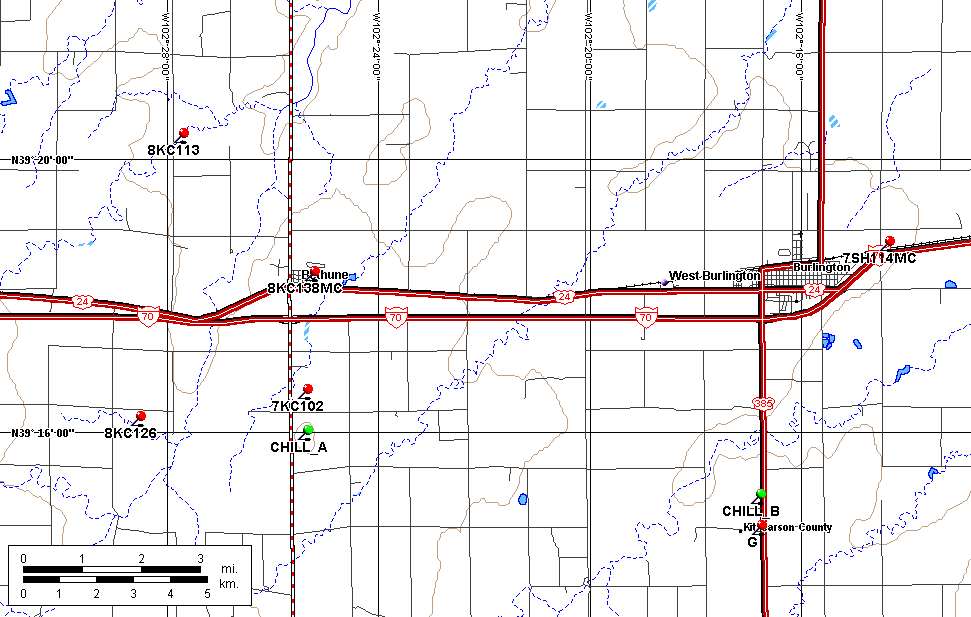
Two possible sites for the CSU-CHILL radar. The first possible site (CHILL_A) is on locally high ground (4100' contour) about 2 miles south of Bethune. The second site (CHILL_B) is on the Burlington-Kit Carson County Airport, on US 385 about 4 miles south of Burlington. The CHILL_B site is also on locally high ground looking to the north but is about 60 m lower in altitude than the CHILL_A site. The `KC'-numbered stickpins indicate the location of weather spotters in the Bethune area.
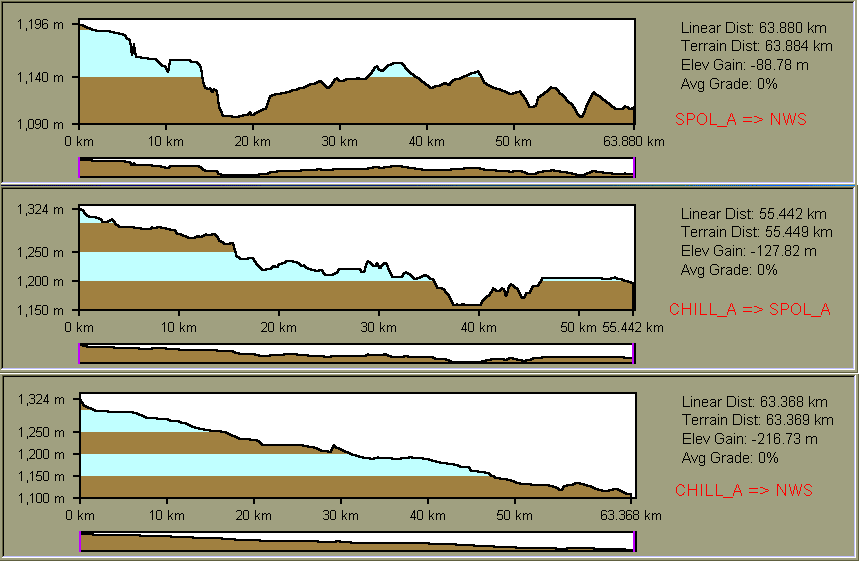
Topographic profiles between the CHILL_A, SPOL_A, and Goodland NWS possible radar sites. The SPOL_A site is assumed to be at the northern end of the N-S leg of US 36 east of Idalia. The triple Doppler baselines are 64 km, 64 km, and 55 km, with the shortest being between the CHILL and SPOL radars. CHILL would have reasonable line-of-site for communications with Goodland.
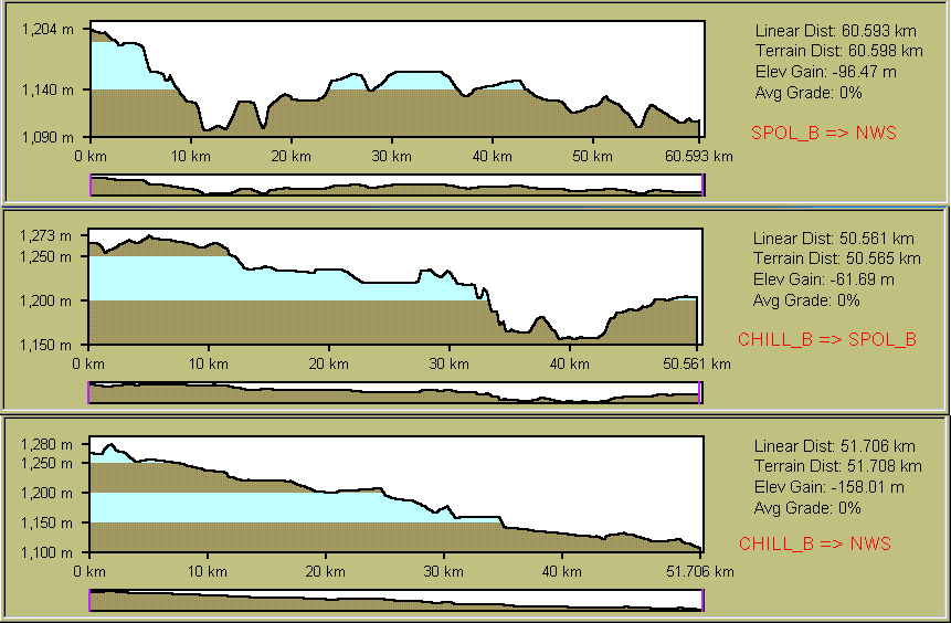
Topographic profiles between the CHILL_B, SPOL_B, and Goodland NWS possible radar sites. In this case, the SPOL_B site is assumed to be at the southern end of the N-S leg of US 36 east of Idalia. (The N-S leg of 36 is almost perfectly flat.) The triple Doppler baselines are 61 km, 51 km, and 52 km, with the longest being between the SPOL and NWS 88D radars. A small (15 m) rise east of Burlington Airport would affect line-of-site with Goodland.